Tag: Middle East

  • How Online Maps Lay Bare the US Military Bases Targeted by Iran

    How Online Maps Lay Bare the US Military Bases Targeted by Iran

    Sign up here to receive Bellingcat’s biggest investigations by email as soon as they are published. Become a member and support our work here.

    In September, CBS News obtained new images of the aftermath of attacks on US bases in the Middle East from active service members. One told the news channel: “This is major damage to our bases that hasn’t been communicated to the American public. “We’re standing there with our eyes closed getting punched in the face,” they added.

    While reports have detailed how Iran used Russian intelligence, including satellite imagery, to identify US troops, ships and aircraft, Bellingcat found that publicly available mapping platforms also reveal detailed and potentially sensitive information about US military bases in the Middle East. 

    Google Maps and other online mapping services contain dozens of labels identifying facilities including headquarters, accommodation, gyms and fuel points. Publicly available photographs and videos, including material published by the US military, provide further details about how these facilities are used.

    Experts told Bellingcat that such information could have helped inform Iranian targeting decisions by revealing where personnel gather and how bases operate. However, they cautioned that Iran would also have had access to other sources of intelligence. Reporting from Reuters earlier this year also highlighted how US officials believed commercially available location data was being used to target US troops in war zones.

    The bases examined by Bellingcat are not secret and have operated for years in a region where US forces maintained a strong sense of security. Joseph Jarnecki, a research fellow at the Royal United Services Institute, said the US had been able to maintain aerial superiority and was understood to have significant air defence capabilities, but that Iran’s missile and drone campaign has undermined both assumptions. 

    Iranian strikes have damaged at least 20 US military sites across Qatar, Bahrain, the United Arab Emirates (UAE), Jordan, Kuwait, Iraq and Saudi Arabia since the conflict began in February this year.

    Governments can request that Google blur or remove sensitive information from its services and Google publishes data on government requests for content removal.

    Bellingcat contacted the US Department of Defense who asked us to reach out to CENTCOM about the details in this story. We also contacted Google. However, we did not receive responses to questions from these respondents before publication.

    We examined four of the largest and most heavily affected US military installations by Iran’s missile and drone campaign: Camp Buehring and Camp Arifjan in Kuwait, Muwaffaq Salti Air Base in Jordan and Al Udeid Air Base in Qatar. At each one, we found publicly available Google Maps information providing details about facilities inside the bases and how they are used.
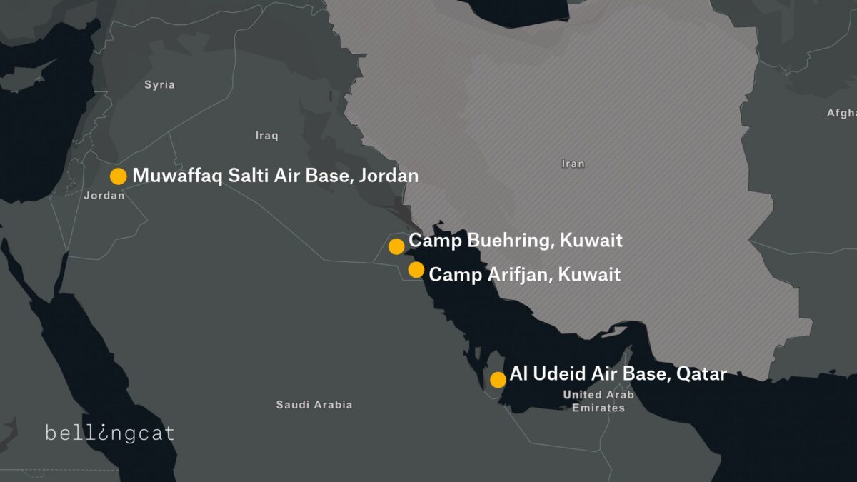
    A map detailing four US bases that were attacked by Iran during 2026 conflict.

    Camp Buehring

    At Camp Buehring in Kuwait, Google Maps identifies what is labelled as the main headquarters building, as well as a gym and a self-help facility, all of which were among locations destroyed by recent Iranian strikes. In addition to Google Maps place markers there are dozens of reviews and user-uploaded photographs.
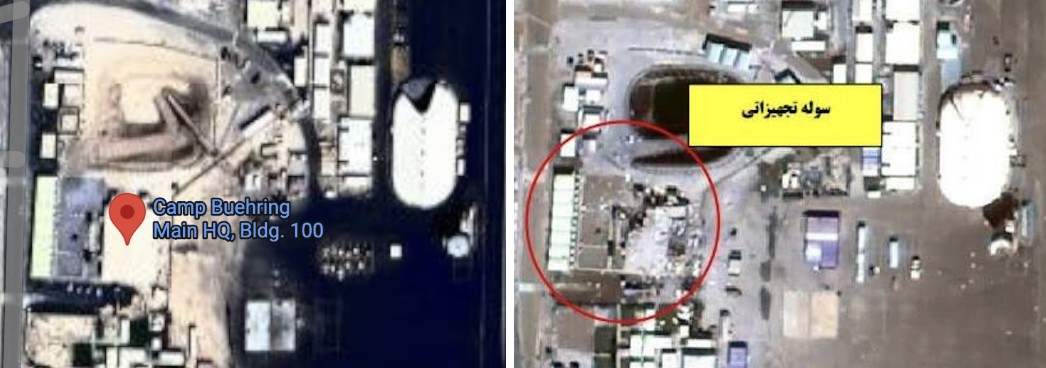
    Left: Screengrab showing “Camp Beuhring Main HQ, Bldg. 100” Google Maps label. Right: Same building seen destroyed on satellite image published by Iran’s Tasnim news agency.
    Left: Screengrab showing “Camp Beuhring Main HQ, Bldg. 100” Google Maps label. Right: Same building seen destroyed on satellite image published by Iran’s Tasnim news agency.

    Bellingcat verified that this was a headquarters building by matching the flagpoles and layout in a photo published by the US military’s Defense Visual Information Distribution Service (DVIDS) showing soldiers posing in front of the  building to the Google Maps satellite image.
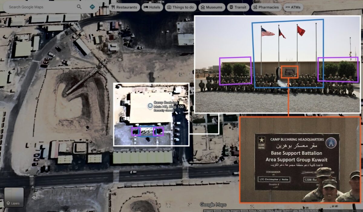
    Geolocation diagram using dvids photo to verify Google Maps Buehring main headquarters location, confirming the accuracy of the Google Maps place marker.
    Geolocation diagram using dvids photo to verify Google Maps Buehring main headquarters location, confirming the accuracy of the Google Maps place marker.

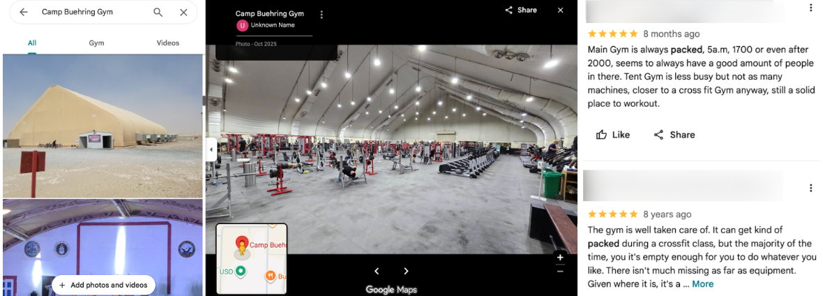
    We also identified details about one of the camp’s gyms, including the building’s layout and roof structure, as well as Google reviews that indicate when it is busiest.
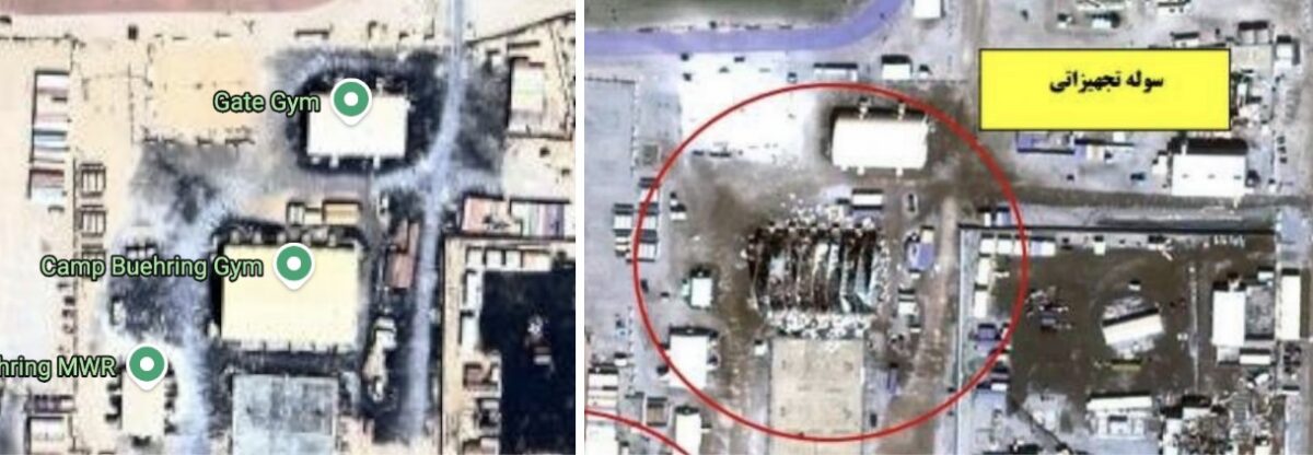
    Left: Google Maps label showing “Camp Beuhring Gym” Right: Destroyed gym building on satellite image published by Iran’s Tasnim news agency on 6 April 2026.
    Left: Google Maps label showing “Camp Beuhring Gym” Right: Destroyed gym building on satellite image published by Iran’s Tasnim news agency on 6 April 2026.

    Among the images published by CBS News in September was that of a heavily damaged tent-like structure with smoke rising from it. Bellingcat matched the location of this image to the above satellite imagery, verifying that it shows the gym building pinned on Google Maps.

    Left: Google Maps shows images of the gym’s interior and exterior. Right: Google Maps reviews indicate when the gym is busy (names blurred by Bellingcat).

    A building labeled on Google as “DPW Self-Help Center” was also destroyed at Camp Buehring. Its Google Maps listing includes opening hours, and a photo posted by a Master Sergeant in 2017 labeled “My office in Kuwait” shows the interior of an office. Some of the notices on the walls inside the office are legible, including what appears to be a floor plan.
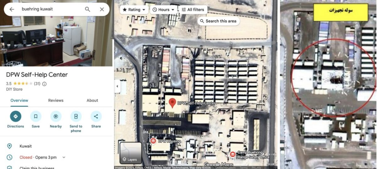
    Left: Google maps “DPW Self-Help Center” listing. Right: Same building seen destroyed on a satellite image published by Iran’s Tasnim news agency on April 6, 2026.
    Left: Google maps “DPW Self-Help Center” listing. Right: Same building seen destroyed on a satellite image published by Iran’s Tasnim news agency on April 6, 2026.

    A Google Maps placemark labelled “Transient Tent” identifies a large accommodation area, while another review includes a ground-level photograph of one of the tents. The dining facility can also be seen from the inside, including information regarding meal times.
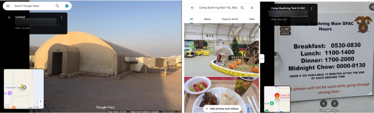
    Left: Google image that appears to show an accommodation area. Right: Photos of the dining facility, including information on meal times (names blurred by Bellingcat).

    William Goodhind of Contested Ground, a visual forensics consultancy that uses OSINT and satellite imagery to analyse military sites, said the information available on Google Maps could reveal “the camp’s layout, the division between secure and non-secure areas, confirms likely accommodation areas, and shows day/time periods of low and high activity.”

    Camp Arifjan

    A satellite image of Kuwait’s Camp Arifjan, captured by Planet on March 4, 2026 and published by the The Washington Post, shows damage to numerous structures at the base. Bellingcat compared the image with publicly available mapping data to identify two damaged facilities.

    A Google Maps listing for a lodging facility labelled “TPE FOR ARIFJAN” includes a soldier’s review discussing room reservations, accommodation shortages and cleaning schedules, indicating that the building was used for military housing. Although Google’s satellite imagery of the base is blurred, the facility is visible in unblurred Bing Maps imagery using coordinates obtained from its Google Maps listing. The satellite image published by The Washington Post shows heavy damage to the facility.
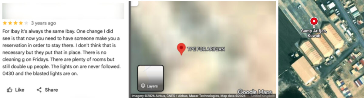
    Left and centre: Blurred Google Maps satellite image with Google review (name blurred by Bellingcat). Right: Unblurred Bing maps satellite image showing the same location.

    A “24hr Fuel Point” tagged on Google Maps is also blurred, but when the coordinates are copied and pasted into Bing Maps a clear satellite image of the fuel station appears. This facility is also seen destroyed on the satellite imagery published by The Washington Post.
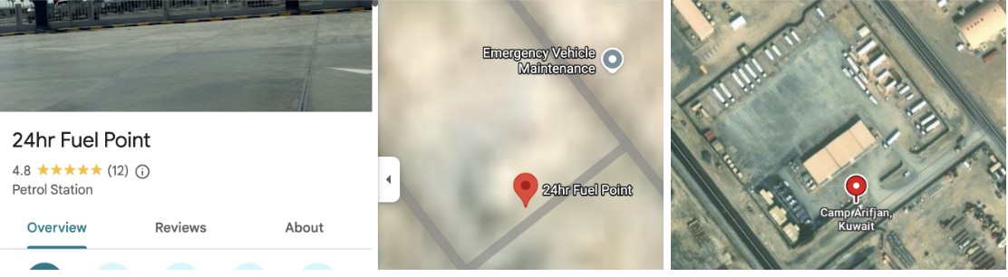
    Left and centre: Blurred Google Maps satellite image with Google review. Right: Unblurred Bing Maps satellite image.
    Left and centre: Blurred Google Maps satellite image with Google review. Right: Unblurred Bing Maps satellite image.

    Bellingcat contacted Microsoft to ask why the facility was not blurred out in the Bing Maps service. A spokesperson said: “When an entity requests removal from visibility on Bing Maps, we work through our process and act accordingly.”

    Muwaffaq Salti Air Base

    Three US service members were killed in Iranian ballistic missile strikes on Muwaffaq Salti Air Base in Jordan on July 17, 2026. The strikes appear to have caused extensive damage to a barracks in the north of the base, with satellite imagery released by Iran showing at least 20 structures destroyed.

    Less than 40 metres from the nearest destroyed structure, and within the same living quarters area, Google Maps reveals the location of an “Airman’s Attic”. These are volunteer-run thrift shops for US Air Force personnel. 

    A five-star review posted last year by a soldier includes a ground-level image of the facility, showing uniform drop-off points and fortifications along the perimeter. The listing provides information about the area’s use, while photographs of the shop’s exterior make it possible to match the satellite imagery to the location on the ground.

    A Sky News investigation also found that 80 percent of the runs shared publicly on the sporting app Strava at Muwaffaq Salti Air Base during the April ceasefire started or finished in this northern barracks.
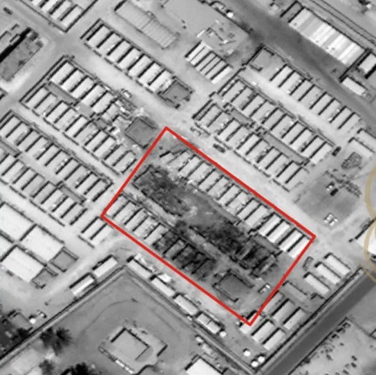
    Satellite image showing damage, highlighted in red, published by Iran’s Fars News Agency.
    Satellite image showing damage, highlighted in red, published by Iran’s Fars News Agency.

    Less than 100 meters from the destroyed area, “LSA DFAC” is pinned on Google maps. “DFAC” is the standard US military acronym for “dining facility”, according to Stars and Stripes. Several Google reviews also discuss the steak being served in this location.
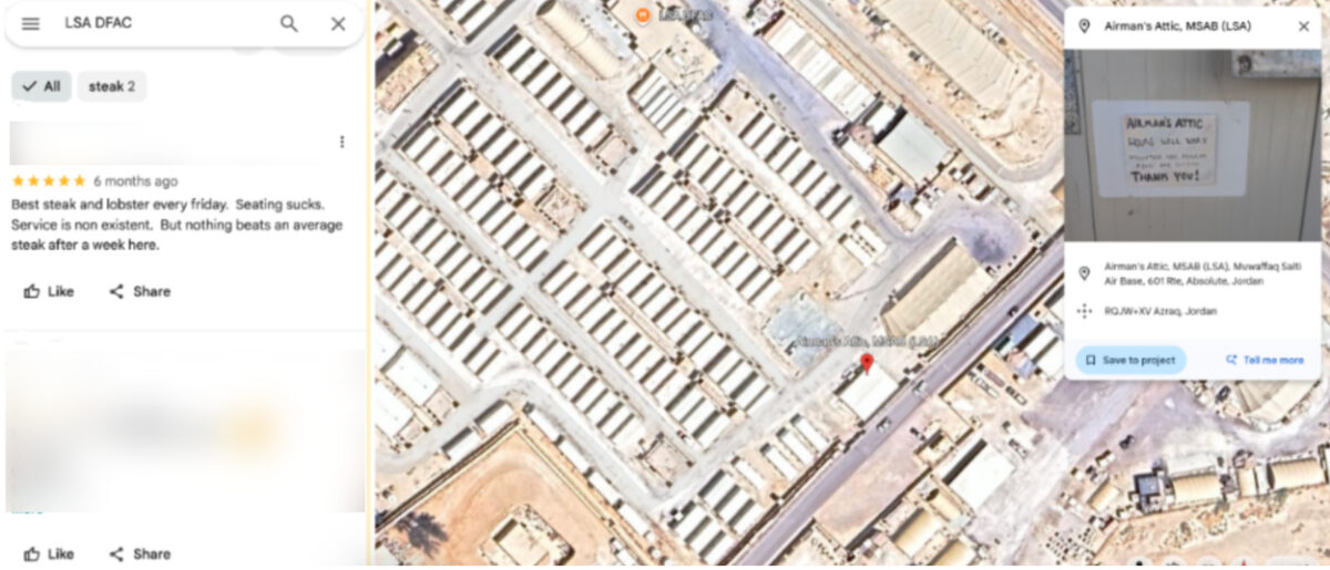
    Left: Google reviews for the dining facility (names blurred by Bellingcat). Right: Google Earth satellite image with the Airman’s Attic and dining facility visible in the area targeted by Iran.

    Al Udeid Air Base

    Similar mapping information is available for Al Udeid Air Base in Qatar, the largest US military installation in the Middle East. 

    The base appears unblurred on Google Maps and entries on the platform identify the functions of numerous buildings. These include lodging facilities, which videos and reviews indicate are used by US Air Force crews and show the interior layout of the facility.
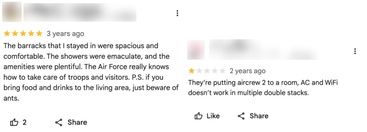
    Google reviews for “Al Udeid Lodging” indicate the presence of US Air Force crews (names blurred by Bellingcat).

    Meanwhile, Russia’s Yandex Maps details the site of two cinemas, a bar and a school on the base. This appears to match information provided on Google Maps.

    While Al Udeid Air Base was damaged during Iranian attacks earlier this year, the areas that were struck do not appear to be among those listed on Google. 

    Business Insider reported that a geodesic dome that housed secure communications equipment was hit in the strikes. ABC News detailed how another building had been damaged near the centre of the base. Google Maps shows a large warehouse-like structure at the location where ABC News reported this strike.

    A New Reality in the Middle East

    Former US Air Force targeting specialist Wes J. Bryant said the problem facing US bases in the Middle East reflected a broader assumption within the military that bases in allied countries were safe from serious attack. He said the belief that these were rear-area bases where “nothing’s going to happen out here” was a fundamental miscalculation, and that the Google Maps issue was an example of the military failing to account for that vulnerability.

    Matthew Savill, Director of Military Sciences at the Royal United Services Institute, said Western militaries do not have consistent policies governing what information can be publicly posted about sensitive sites. He said the issue needs to be considered before a conflict begins, rather than when attacks are already underway. “The start point should be, can we enforce operational security discipline?” Savill pointed to restrictions already in place at some UK military facilities, including Faslane, a naval base that houses the UK’s nuclear submarines, where he said personnel are not permitted to use mobile phones on site.

    Savill told Bellingcat that the different pieces of data available on Google Maps, even if outdated, provided a “pattern of life” about US bases in the Middle East. But he added that the use of Google to help with the military targeting of Western bases is not new, saying he encountered the issue while deployed to Iraq more than 20 years ago.

    “When I was in Iraq, we knew for a fact that insurgents and militants had been using commercial imagery, including Google Earth, to try and map our bases,” he said. “We have known for more than 20 years that there is a vulnerability that if you don’t stop the collection and layering of data early on, that your bases can be heavily mapped.” 

    The use of open-source information to support military targeting has been documented in Ukraine. In 2022, Foreign Policy detailed how Ukrainian private intelligence company Molfar used photographs of Russian soldiers published by Russian media alongside Google Earth satellite imagery to identify their location. Molfar passed its findings to Ukrainian intelligence, and the site was subsequently struck by the Ukrainian military.

    The security risks of publicly mapping military installations were recognised by the US military in 2008, when the Pentagon banned Google’s Street View from documenting the interiors of its bases. Since the Iran war started, US military commanders have also warned service members about posting photographs and videos from bases after Iranian attacks, cautioning that such footage could help Iran assess the effects of its strikes.

    Iranian attacks have forced US personnel to evacuate many additional locations that were deemed too vulnerable to further strikes. 

    In total, 23 US service members have been killed and 865 wounded in the US-Iran war, according to the Pentagon.


    Bellingcat’s Jake Godin, Charlotte Maher and Merel Zoet contributed to this report.

    Bellingcat is a non-profit and the ability to carry out our work is dependent on the kind support of individual donors. If you would like to support our work, you can do so here. You can also subscribe to our Newsletter and follow us on Bluesky here, Instagram here, Reddit here and YouTube here.

    Source: Bellingcat · 2026-11-05

  • The Flashpoint Threat Intelligence Brief: Middle East

    The Flashpoint Threat Intelligence Brief: Middle East

    Blog

    The Flashpoint Threat Intelligence Brief: Middle East

    Flashpoint’s weekly analysis tracks shifting kinetic and cyber threat radiuses, geopolitical disruptions, and provides critical operational forecasts for the ongoing Middle East conflict.

    Default Author Image
    October 30, 2026

    Following Operation Epic Fury, regional kinetic operations have transitioned into direct, persistent threats against commercial shipping, energy infrastructure, and critical supply chains.

    The Flashpoint Threat Intelligence Brief: Middle East cuts through headline noise to deliver tactical, ground-level intelligence for government agencies, corporate security leads, and global logistics teams—turning Flashpoint’s primary source intelligence into proactive risk mitigation.

    Here are the updates from this week that your security operations team should be tracking.

    Operational SITREP: Executive Summary

    Between October 23 and October 29, Ansarallah (the Houthi movement) continued its campaign against Saudi aviation, military, and energy infrastructure. Houthi military spokesperson Yahya Saree claimed ballistic missile and drone strikes on King Khalid International Airport, Saudi Aramco facilities in Yanbu, crude oil pumping stations, and the Ras Tanura refinery. On October 27, the group also claimed to have struck Saudi Arabia’s Ministry of Defense headquarters in Riyadh and military transport aircraft at Abha airport along with King Khalid Air Base. Saudi authorities have not confirmed damage at several of these sites.

    Saudi-led coalition forces reported intercepting missiles and drones targeting Riyadh, Khamis Mushait, the Eastern Province, and other areas, including 10 ballistic missiles directed toward southern Saudi Arabia on October 25. King Khalid International Airport resumed international flights that day, although Ansarallah warned airlines that the airport remained a military target. Coalition air strikes continued in northern Yemen, with the Sanaa-based Health Ministry reporting eight fatalities following a strike on workers’ housing in Hamdan.

    Houthi ground operations also intensified around Taiz and Lahj, with reported advances along the Jabal Sabr front and an assault on Al-Maqatira Castle. On October 29, Yemeni government forces reported that Ansarallah fired two ballistic missiles at Aden International Airport, extending the threat to another major aviation facility.

    The United States ordered nonessential staff and families to depart its embassy in Riyadh and consulates in Jeddah and Dhahran following statements by Islamic Revolutionary Guard Corps (IRGC) officials identifying American diplomats as legitimate targets. Similar precautionary measures were reported at US missions elsewhere in the Middle East. US officials also cited intelligence indicating potential Iranian assassination planning against American diplomatic and government personnel.

    Iran continued operations against Kurdish opposition groups in Iraq, with the IRGC conducting a drone strike on a Komala facility near Erbil on October 24. Maritime incidents persisted near the Strait of Hormuz, including a UKMTO report of a vessel on fire north of Khasab, Oman on October 29. The IRGC Navy separately claimed to have electronically seized and landed a US drone west of the strait, although that claim remains unverified.

    In the cyber domain, researchers from TrendAI, Citizen Lab, and Confiant identified additional surveillance activity involving Israeli advertising technology firm Discover-Tech. The company reportedly bid on advertising traffic associated with Starlink users in more than 100 countries, enabling potential identification and geolocation of individuals in conflict-affected regions. Google and Comcast subsequently removed the firm from their advertising platforms.

    Kinetic & Maritime Risk

    The resumption of international flights at King Khalid International Airport does not eliminate the risk of further disruption. Ansarallah has continued to designate the airport as a military target, while missile interceptions have created additional hazards for surrounding communities. In Khamis Mushait and Ahad Rafidah, falling debris injured two people and damaged residential buildings and vehicles. Similar debris was reported across parts of western Saudi Arabia, including areas around Jeddah, Taif, and Rabigh.

    In Yemen, Houthi advances along the Jabal Sabr front have brought fighting closer to government-held positions overlooking Taiz, including areas near Taiz University. The expanding offensive threatens access routes around a city where the UN has warned that approximately 800,000 people urgently need humanitarian assistance. Continued operations in Lahj and attacks toward Aden add further uncertainty for transport and government facilities in southern Yemen.

    Western-linked personnel and facilities face increased exposure following Iranian threats against American diplomats. The US drawdown extends beyond Saudi Arabia, with similar precautionary measures reported at diplomatic missions in the UAE, Lebanon, Qatar, Jordan, Bahrain, and Kuwait. Iranian allegations that US aircraft are operating from Gulf states could also increase the risk of Tehran identifying host-nation military facilities as potential targets in a renewed confrontation.

    At sea, the reported incidents near Khasab and Iraq’s Al-Faw port highlight risks across both the Strait of Hormuz approaches and the northern Gulf. The reporting identifies 113 maritime attacks in and around the Strait of Hormuz since February 28, underscoring the sustained exposure of commercial vessels operating through the region.

    Cyber and Hybrid Risk

    The latest Discover-Tech findings raise particular concerns about the information exposed through real-time advertising auctions. Researchers found that the firm could use advertising bid requests to identify and geolocate Starlink users, with activity concentrated in countries affected by conflict or political instability. This creates potential surveillance exposure for personnel relying on satellite internet services in areas where other communications infrastructure may be limited or disrupted.

    The research also builds on earlier findings connecting Discover-Tech to the delivery of Candiru spyware through online advertisements. Although advertising-based tracking does not itself establish that a device was compromised, the ability to identify and locate specific users could support subsequent targeting. Google and Comcast’s removal of Discover-Tech from their advertising platforms represents a response to the reported activity.

    Separately, the IRGC Navy’s claimed electronic takeover of a US drone near the Strait of Hormuz remains unverified. If substantiated, the incident would indicate an electronic warfare capability relevant to unmanned aircraft operating near Iranian-controlled waters. Iran’s announcement of arrests involving alleged US- and Israel-linked intelligence cells also reflects its continued focus on identifying suspected foreign intelligence activity, although the alleged affiliations have not been independently established.

    Recommended Risk Posture and Protective Controls

    Organizations with personnel, facilities, or operations exposed to the conflict should maintain heightened awareness of physical security, travel, maritime, and surveillance risks.

    Cyber Defense

    • Limit advertising-based tracking: Organizations with personnel using Starlink or other satellite internet services in conflict zones should review network- and browser-level ad blocking, restrict advertising identifiers on managed devices, and assess exposure of location and device data through advertising systems.
    • Review counterintelligence exposure: Organizations with personnel or partners traveling to Iran should limit the sensitive information carried on devices, review communications practices, and reinforce check-in procedures in light of recent arrests of alleged foreign-linked cells.

    Physical and Operational Defense

    • Strengthen protections for US-linked personnel: Organizations supporting diplomatic missions or employing current and former US government officials should review travel, residence, and event security in response to reported Iranian threats.
    • Reassess Saudi Arabia travel and facility plans: Confirm flight status before travel, review shelter procedures, and account for the risks associated with missile interception debris, particularly in Riyadh, Jeddah, Dhahran, and southern Saudi Arabia.
    • Maintain heightened maritime security: Shipping operators should monitor UKMTO advisories, review transit risks near Khasab and Al-Faw, and reinforce crew readiness for fires and other onboard emergencies.
    • Review exposure near Erbil: Organizations operating in Iraq’s Kurdistan region should assess proximity to Iranian Kurdish opposition facilities and update shelter and personnel-accountability procedures following repeated IRGC strikes.

    Strategic Outlook: Operational Forecast

    Over the next 48–72 hours, Houthi forces are likely to sustain missile and drone attacks against Saudi aviation, energy, and military infrastructure while continuing operations around Taiz, Lahj, and Aden. The resumption of international flights at King Khalid International Airport does not eliminate the threat of renewed disruption, particularly given Ansarallah’s continued designation of the airport as a target. Saudi-led coalition strikes in northern Yemen are also likely to continue.

    The US diplomatic drawdown reflects heightened concern about threats to American personnel, while reported planning for additional US strikes against Iran introduces uncertainty ahead of the November 3 midterm elections. Iranian Foreign Minister Abbas Araghchi’s statements about continued diplomatic contacts suggest negotiations remain possible, although no breakthrough has been reported.

    Maritime incidents near the Strait of Hormuz and northern Gulf are likely to persist, with additional uncertainty surrounding the IRGC’s claims of electronic warfare operations against US aircraft. Iranian strikes against Kurdish opposition positions near Erbil may also continue, alongside further counterintelligence arrests and public accusations of foreign involvement.

    In the cyber domain, the latest Discover-Tech findings may prompt additional scrutiny of advertising-based surveillance and the exposure of satellite internet users in conflict-affected regions.

    Enhance Threat Intelligence Using Flashpoint

    As the conflict continues to affect military operations, commercial shipping, regional infrastructure, and digital communications, security teams need timely intelligence to assess emerging risks and protect their organizations.

    Flashpoint combines primary-source monitoring, open-source intelligence, and geospatial analysis to help organizations identify developing threats, assess operational exposure, and make informed security decisions.

    Request a demo to learn how Flashpoint supports physical security intelligence, threat monitoring, and operational risk assessment.

    Frequently Asked Questions (FAQs)

    What is the Flashpoint Physical Threat Intelligence Brief?

    The Flashpoint Physical Threat Intelligence Brief: Middle East is a recurring threat intelligence update that translates raw primary-source open-source intelligence (OSINT) and geospatial data into actionable physical security analysis. It focuses on kinetic conflict developments, standoff weapon capabilities, maritime corridor security, and critical infrastructure risks across the Middle East.

    How does Flashpoint gather physical security intelligence for the Middle East?

    Flashpoint Physical Security Intelligence (PSI) gathers data by combining global open-source intelligence (OSINT), geolocated social media signals, satellite imagery, and primary-source threat monitoring. The platform uses AI-driven natural language processing and geospatial mapping to track kinetic developments, weapon strike radiuses, and physical security threats in real time.

    See Flashpoint in Action

    Source: Flashpoint · 2026-10-30

  • EU Satellite Imagery Delayed Over Gaza and Parts of West Bank by 24-hours

    EU Satellite Imagery Delayed Over Gaza and Parts of West Bank by 24-hours

    Sign up here to receive Bellingcat’s biggest investigations by email as soon as they are published. Become a member and support our work here.

    Imagery captured by the European Space Agency’s freely available Sentinel-2 and Sentinel-1 satellites appears to be delayed over Gaza and parts of the West Bank, a Bellingcat analysis has found.

    While the delay remains relatively short at just 24 hours, this can still impact the speed at which analysts and researchers can observe what is happening in the region.

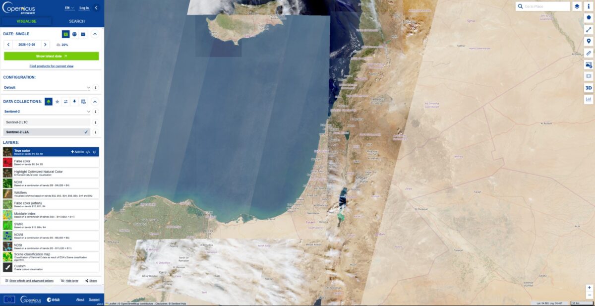
    For example, the Israeli Defence Forces demolished homes in the West Bank Palestinian city of Hebron in recent days. New imagery captured on October 26, which included Hebron, would allow open source researchers to quickly confirm the demolitions, assess the impacted area and observe any unreported IDF activity. But imagery for the western half of Hebron was not available until October 27 due to the Sentinel-2 delay, inhibiting real-time fact-checking and reporting on this evolving situation.

    A spokesperson for the European Union told Bellingcat that the delay was not related to events in Gaza but to “mitigate possible threats” due to the war in the Middle East “including Iran’s attacks on its neighbours and possible threats to European interests”. The delayed region of Sentinel tiles that cover Gaza as well as parts of Israel and the West Bank also extends over the Eastern Mediterranean Sea.

    The European Union ordered a 24-hour delay on Sentinel satellite imagery over the Gulf of Oman earlier this year during US and Israeli strikes on Iran. However the delay impacting Gaza and parts of the West Bank has not been announced or previously reported.

    “Such decisions are taken unanimously by all EU Member states and will stay in place as long as necessary,” the spokesperson said. They also said that while the Copernicus program, which includes the Sentinel satellites, operated a free and open data policy there were limitations to this for security. 

    When asked if the delay, which began in late March, was related to the presence of US vessels in the Eastern Mediterranean or if there were other areas of delay, the spokesperson said they had no further comment.

    Sentinel Delays

    The Sentinel-2 and Sentinel-1 satellites provide an invaluable source of imagery for open source researchers. This has been especially true this year, as commercial satellite imagery providers restricted access to imagery in the Middle East, including areas of active human rights concern, such as Gaza. 

    However, in July, the European Union published Council Decision 2026/1716, which ordered a 24-hour delay on Sentinel imagery over the Gulf of Oman, after a request from the US government which was involved in strikes on Iran at that time.

    Just two weeks later, the European Union issued a corrigendum that unpublished decision 2026/1716 and removed it from the Council of the European Union record, although satellite data shows the delay has remained. 

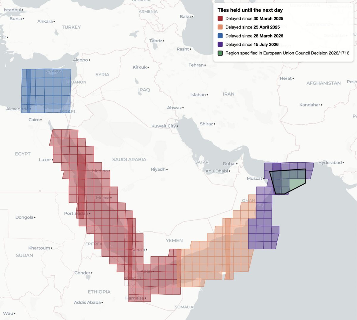
    This decision, while it was available, was reportedly the first public notification of delayed Sentinel imagery. Yet it was not the first time that Sentinel imagery has been restricted, analysis shows. Bellingcat found four distinct regions of delayed satellite imagery during 2025 and 2026: the Gulf of Oman, the Gulf of Aden/western Arabian Sea, the Red Sea as well as the previously unreported delay in the Eastern Mediterranean Sea and parts of Israel, the West Bank and the entirety of Gaza.

    Bellingcat’s analysis shows the regions where Sentinel-2 imagery is subject to a 24-hour delay, and when the delay was imposed. Only the July 15, 2026 delay over the Gulf of Oman was referenced by European Commission directives and the region referenced in 2026/1716 encompasses only a portion of the delayed tiles.

    Bellingcat’s analysis shows that these delays have been implemented in stages. Twenty-four hour delays of Sentinel-2 imagery were first observed by open source researchers in March and April 2025 after the US launched a naval and air strike campaign against Houthi targets in Yemen. 

    The previously unreported imagery delay in the Eastern Mediterranean began on March 28, 2026, the same month that commercial American space imaging company Planet Labs also restricted imagery across the Middle East. The Gulf of Oman delay began on July 15, 2026, two days after the publication of Council Decision 2026/1716.

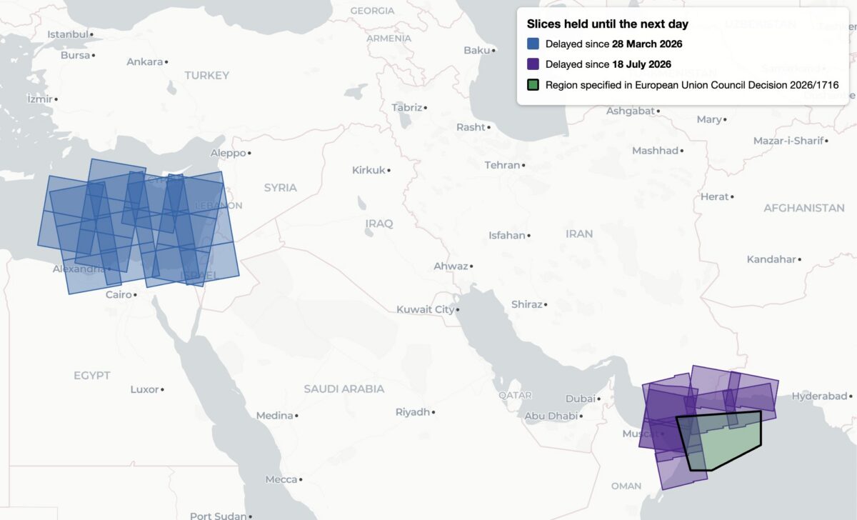
    Decision 2026/1716 also specified that the delay be implemented for both Sentinel-2 and Sentinel-1 radar imagery. Bellingcat’s analysis of Sentinel-1 image availability shows that this is the case for both the Gulf of Oman region and the unreported region over the Eastern Mediterranean Sea. However, the 2025 restrictions on Sentinel-2 imagery in the Red Sea and Gulf of Aden are not implemented in Sentinel-1. 

    Sentinel-1 imagery uses “synthetic aperture radar” to capture lower resolution radar images that can collect data at night and on cloudy days. This differs from Sentinel-2, which captures optical satellite imagery at higher resolution.

    Bellingcat’s analysis shows the regions where Sentinel-1 satellite imagery is subject to a 24-hour delay and when that delay was imposed.

    A Tale of Two Tiles

    Sentinel satellite imagery is most commonly accessed by open source researchers through Copernicus Browser, a free online platform, but it is also distributed as large tiled files in the Copernicus Data Space Ecosystem. These tiles are numbered using the Military Grid Reference System, and can be listed using APIs that provide information on each tile, including the capture and publication time. By comparing the capture and publication time, the publication delay can be computed.

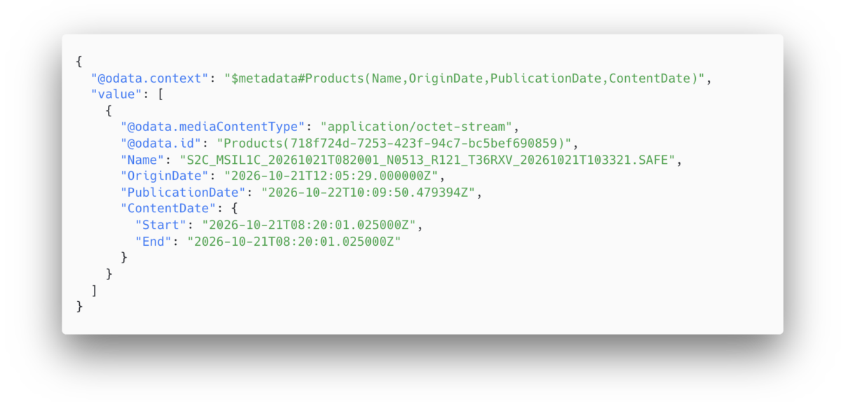
    For example, the catalog information for the tile T36RXV, which includes Gaza and portions of the West Bank, Negev and Egypt, provides the following metadata for the October 21, 2026 capture.

    Metadata from tile T36RXV, which includes Gaza and portions of the West Bank, Negev and Egypt.
    Metadata from tile T36RXV, which includes Gaza and portions of the West Bank, Negev and Egypt.

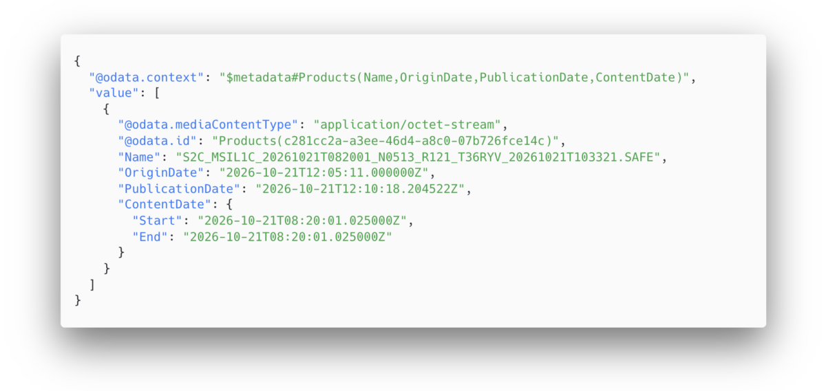
    This shows that while the image was captured at 08:20 UTC on October 21, it was not published until 10:09 UTC on October 22 — almost 26 hours later. This is in contrast to the neighboring tile T36RYV, which includes parts of the West Bank, Israel, and Jordan. API data for this tile shows that the image was published at 12:10 UTC on October 21, just under four hours after the capture time.

    Metadata from tile T36RYV, which includes parts of the West Bank, Israel, and Jordan.
    Metadata from tile T36RYV, which includes parts of the West Bank, Israel, and Jordan.

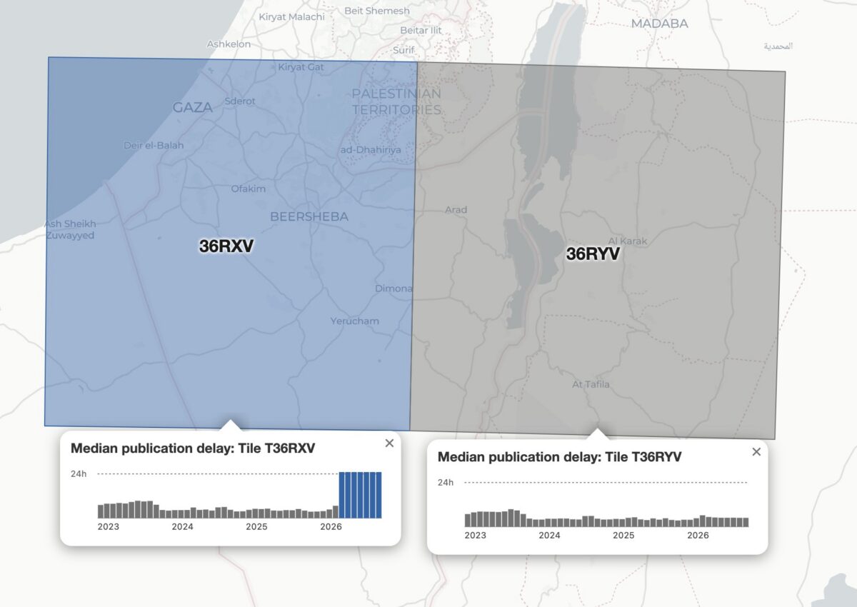
    This difference is not unique to this date either. Bellingcat’s analysis shows that this tile has been consistently delayed by one day since March 28, 2026.

    Graphing the publication delay for two adjacent Sentinel-2 tiles shows a clear difference beginning March 28, 2026.
    Graphing the publication delay for two adjacent Sentinel-2 tiles shows a clear difference beginning March 28, 2026.

    This method can be extended further, and by analysing every tile with valid publication date timestamps, Bellingcat identified all global Sentinel-2 and Sentinel-1 delays since 2023. The only consistent delays visible were those identified in the Gulf of Oman, the Gulf of Aden/western Arabian Sea, the Red Sea and Eastern Mediterranean in 2025 and 2026.

    Impact on open source investigations

    While the 24-hour delay on certain Sentinel imagery is a less severe restriction than other satellite providers have imposed, it can still impact the open source research process in fast moving situations. This is especially so in recent months as the European Space Agency’s Sentinel satellite data has emerged as a refuge as other satellite data is censored.

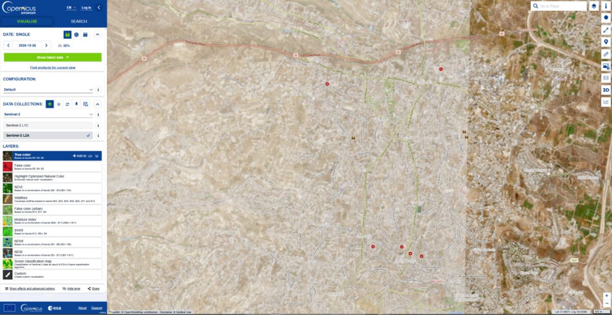
    The image below shows how imagery for the eastern half of Hebron was visible on October 26, but not the western half where demolitions took place earlier this week.

    The city of Hebron, Palestine, seen in Copernicus Browser on October 26, 2026. While imagery is available for the eastern half of the city, there is no recent imagery of the western half.
    The city of Hebron, Palestine, seen in Copernicus Browser on October 26, 2026. While imagery is available for the eastern half of the city, there is no recent imagery of the western half.

    The shape of the missing tiles can be seen by zooming out within the Copernicus browser, demonstrating how imagery of Gaza and other parts of Israel and the West Bank are also delayed.

    The missing tiles also include Gaza, parts of Israel, Egypt, and Cyprus, and the Eastern Mediterranean Sea.
    The missing tiles also include Gaza, parts of Israel, Egypt, and Cyprus, and the Eastern Mediterranean Sea.

    Sentinel imagery covering western Hebron after the demolitions took place was published on October 27. However, the delay prevented local reports from being verified with satellite imagery while the situation was still ongoing.

    Some Sentinel-2 users have previously described the challenges of covering fast-moving issues in the Gulf of Oman when the Sentinel delay was announced in March.


    Bellingcat is a non-profit and the ability to carry out our work is dependent on the kind support of individual donors. If you would like to support our work, you can do so here. You can also subscribe to our Newsletter and follow us on Bluesky here, Instagram here, Reddit here and YouTube here.

    Source: Bellingcat · 2026-10-29

  • Viral Google Maps Images Shared Widely This Week Show Gaza Ruins. We Obtained More Recent Satellite Imagery

    Viral Google Maps Images Shared Widely This Week Show Gaza Ruins. We Obtained More Recent Satellite Imagery

    Earlier this week, several viral social media posts and news articles stated that Google had updated satellite imagery over Gaza.

    The imagery shared in these posts and articles shows several areas, including the southern city of Rafah. Huge destruction is detailed in the images, including what appears to be entire neighbourhoods flattened

    But the imagery wasn’t entirely new. 

    A Google spokesperson told Bellingcat that they regularly updated third-party satellite images and that the latest Gaza imagery had actually been available since June 2026. 

    Social media posts from earlier this year also detailed how Google Earth Pro users (a program that needs to be downloaded) had been analysing what appears to be the same imagery that was showcased this week by media outlets as early as May.

    Bellingcat has access to satellite imagery from commercial space company Planet Labs, which shows further destruction in Rafah after the June Google update.

    The Planet Labs imagery also gives insight into destruction further north in Gaza as recently as September.

    Demolitions and Destruction Continue

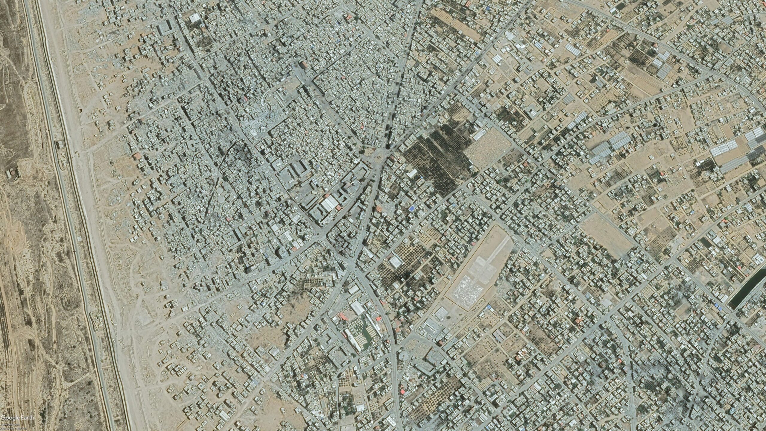
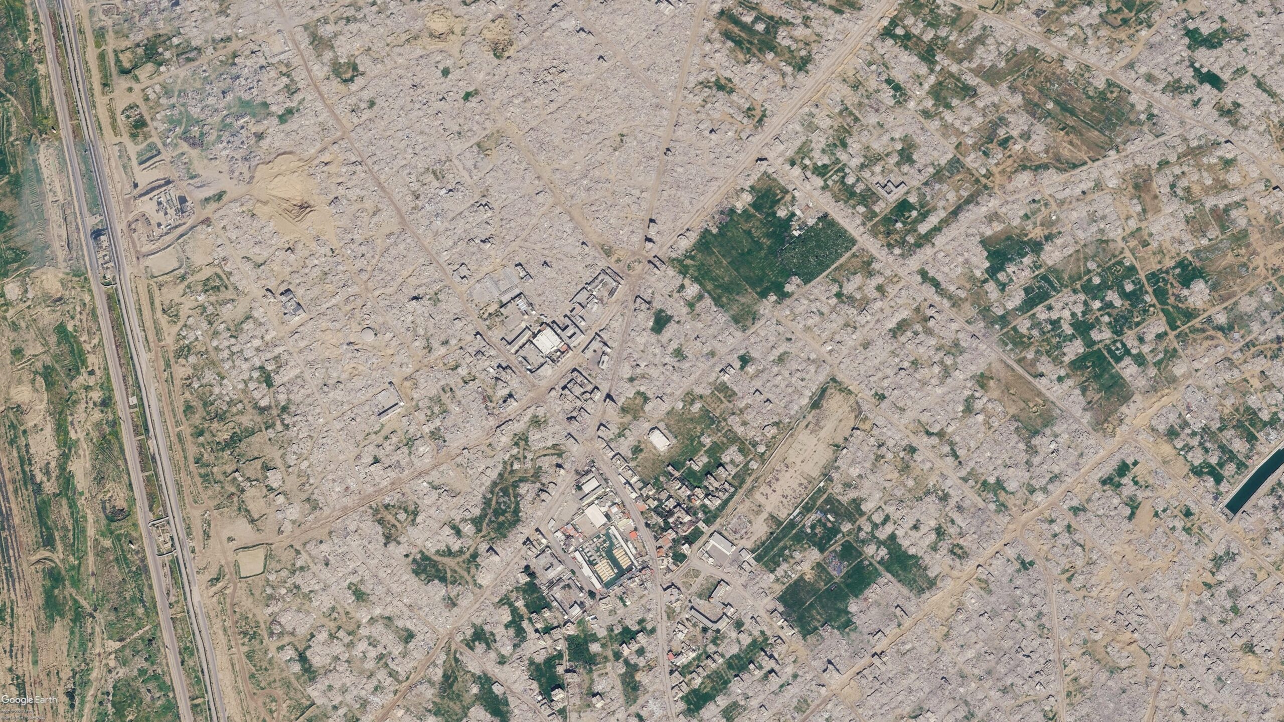
    The Google imagery updated in June showed a satellite image captured by the Airbus satellite imagery provider several months prior, in February 2026. 

    When compared to a previous image of the same area that was published and visible on Google in June 2024, the difference is stark. Entire neighbourhoods have been razed while several school facilities near the Tal as Sultan area appear to be among the most prominent buildings still standing.

    Satellite imagery shows visible changes across Rafah between June 2024 (left) and February 2026 (right). Image credit: Airbus via Google Earth.

    Bellingcat previously reported on this destruction when it first started taking place in 2024. And the demolitions have continued since Google published its latest Airbus images in June.

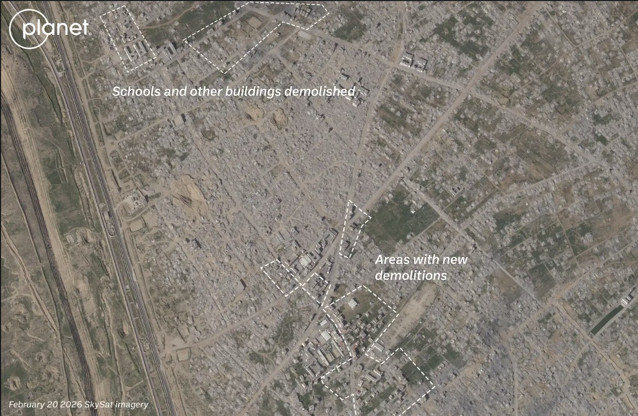
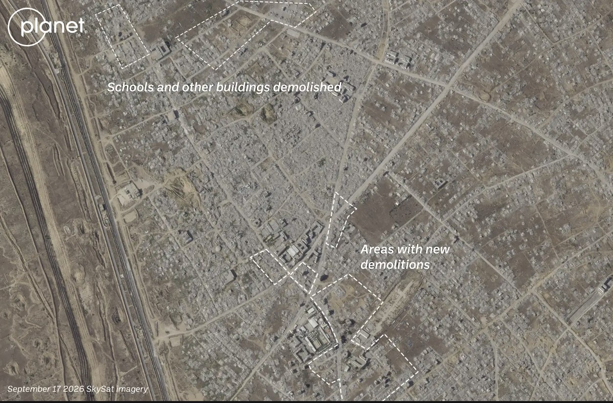
    The most recent high resolution imagery from Planet Labs, which uses its own constellation of satellites called SkySat, was taken in September. This was seven months after those now displayed on Google, and shows buildings near Rafah’s municipal stadium have now been demolished. 

    A number of schools and other buildings near the Tal as Sultan area previously still standing to the northwest of the stadium are also now shown to have been demolished in the September imagery.

    Satellite imagery shows visible changes across Rafah between February 2026 (left) and September 2026 (right). Image credit: Planet Labs PBC.

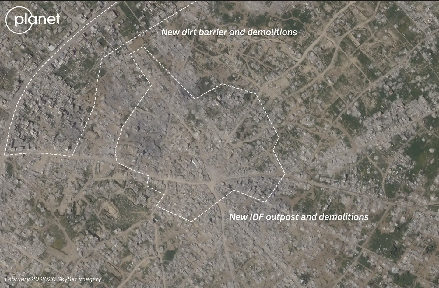
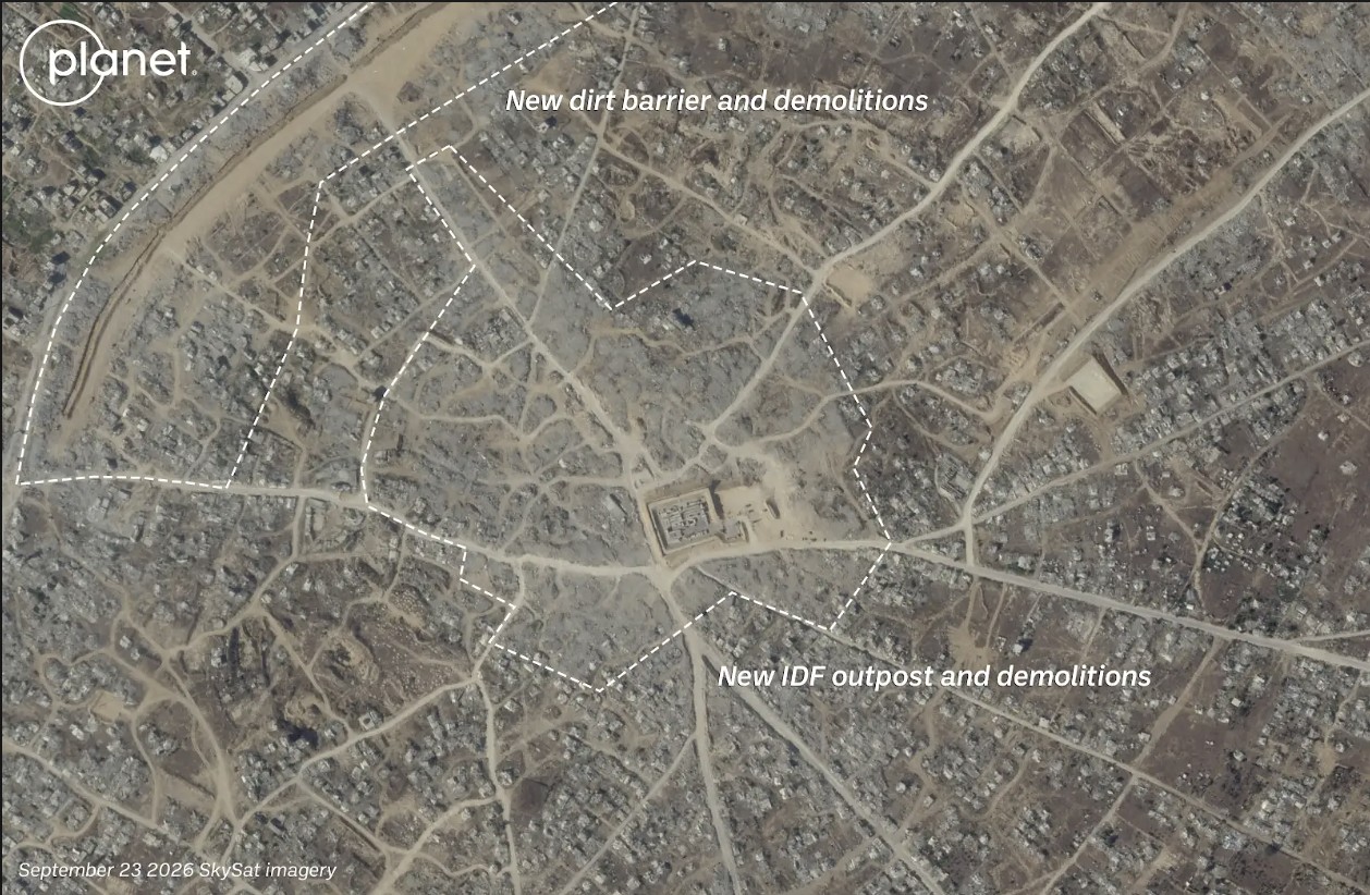
    The centre of Bani Suheila, a town just to the east of Khan Yunis in southern Gaza, also looks drastically different from how it appears in the Google imagery. 

    While most of the buildings surrounding the centre of the town are visibly damaged or destroyed in the Airbus imagery, updated imagery from Planet shows that even more of the buildings have been reduced to rubble, with an IDF outpost now visible on top. A large earthen barrier is also visible, cutting through the town from north to south.

    Satellite imagery shows visible changes in town of Bani Suheila between February 2026 (left) and September 2026 (right). Image credit: Planet Labs PBC.

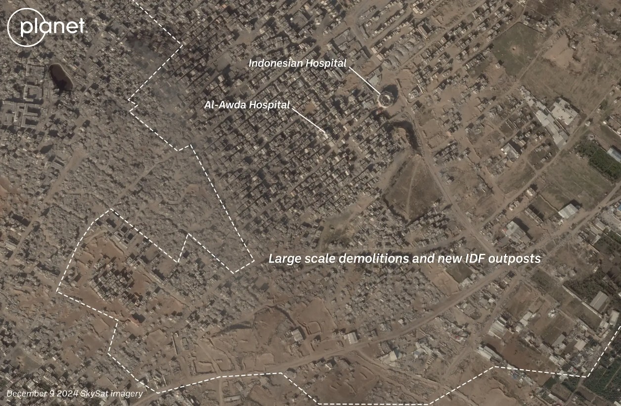
    Recent Planet Labs imagery also shows the level of destruction in northern Gaza, primarily in the eastern areas of the towns of Shujaiya and Jabaliya.

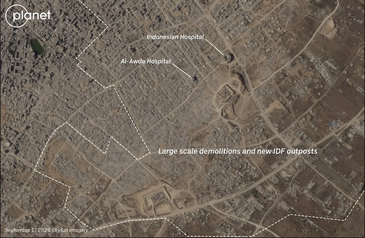
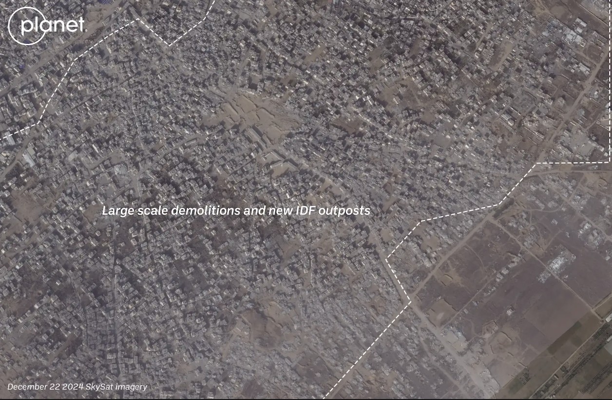
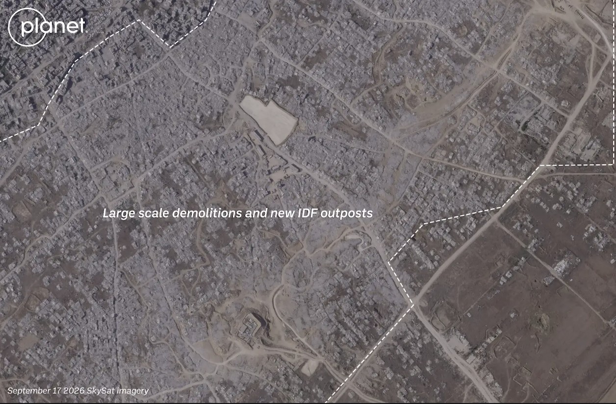
    Satellite imagery shows visible changes in town of Jabaliya between December 2024 (left) and September 2026 (right). Image credit: Planet Labs PBC.

    Both Shujaiya and Jabaliya were already heavily damaged before the most recent ceasefire. Satellite imagery shows that the IDF has continued razing large parts of both neighbourhoods while building outposts.

    Satellite imagery shows visible changes in town of Shejiya between December 2024 (left) and September 2026 (right). Image credit: Planet Labs PBC.

    Earlier this week, reports also surfaced that an Israeli satellite imagery provider had released images over northern Gaza before they were taken down.

    Satellite images such as these appear to show that Israel has not stopped reducing buildings in Gaza to rubble despite the continuation of an official ceasefire.

    Israel previously told media that the mass demolitions were part of an effort to “demilitarise” Gaza. 

    According to United Nations data, about 82 percent of the structures in Gaza are damaged, with two -thirds of them destroyed. 

    With international journalists still widely unable to enter Gaza freely, satellite imagery remains one of the only ways to assess the true scale of destruction and to understand what is happening on the ground.


    Bellingcat is a non-profit and the ability to carry out our work is dependent on the kind support of individual donors. If you would like to support our work, you can do so here. You can also subscribe to our Newsletter and follow us on Bluesky here, Instagram here, Reddit here and YouTube here.

    Source: Bellingcat · 2026-10-01